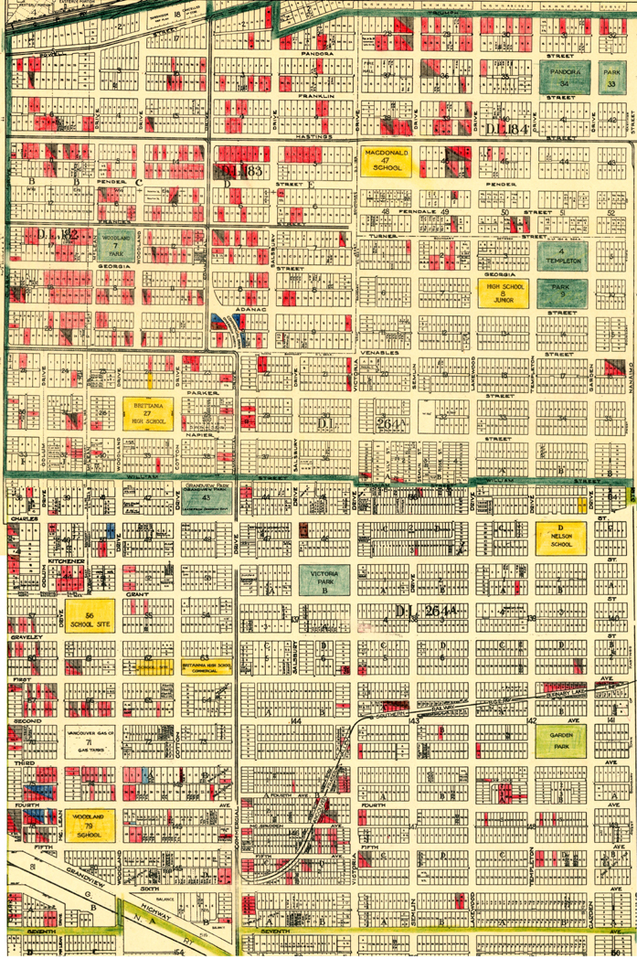
Here is a map prepared by the City of Vancouver that shows almost all of Grandview in 1945.
 This image is constructed from two maps (343.10 and 343.11) in the City of Vancouver Archives collection. The series of maps is captioned as being “hand coloured to show tax sale property for sale, property with no water, street widening and drainage, replotting, reserved land for schools, reserved land for parks, sundry land, capital assets not including schools and parks, schools, and parks, as applicable.” It is not clear what colours are meant to represent what item but, from other data I have collected, I would suggest that the houses marked in red were those in tax trouble.
If you zoom in on your screen you can see a great deal of detail.

Was that railway actually still there in 1945 (the one running up 2nd Ave on the map)?
Is the funky dupex stone-faced house part of the railway? I recall hearing that it was, but I had trouble believing there was a railway there.
LikeLike
Hi there: Yes the interurban tracks were not pulled up until the 1950s. The loop at the Commercial end eventually became McSpadden Park, I’m not sure which “funky” house you mean though.
LikeLike
It is a very distinctive small stone duplex, i tried finding it with google streetview but no luck. I will find it “live” and report the address. It looks like a house with a story.
LikeLike
Here is the house I am referring to:
http://postimg.org/image/a0160xs5n/
LikeLike
Hi there: That is 2033-35 E. 2nd Avenue (lots 18-19 on block 143B of D/L 264A) which was custon-built as a duplex in 1912. Parkins & Cotton got the building permit on 17th July 1912 and valued the building at $3,500.
I don’t see any connection with the interurban other than its proximity, but any new document would be a valuable addition to the little knowledge we have.
LikeLike
I’ve long wondered about that duplex too. The fact it’s made of stone when so little else around here is, does make it stand out as you walk along 2nd. Perhaps that wasn’t as unusual a building material back then? (Though with such plentiful supplies of wood around I’d be surprised.)
LikeLike
From what I gather, my older brother and cousins said that particular house belonged to the owner of the saw mill that was located on the corner of Semlin and East 2nd. On that corner, there are currently 4 or 5 70’s style box homes, heading eastward up the hill towards that big house. The sawmill was where those houses are. Speaking of McSpadden park…does anyone remember the candy store that was there..on about 4th or 5th and Victoria?
LikeLike